Just keep an eye on your inbox for a confirmation email.
Stay connected
Keep updated on:
Funding programs
Stories on cutting-edge research
Events... and more
Article
High-tech health checks for Canadian forests
How remote sensing can assess trees faster and better — and identify climate-smart seedling choices
Published
Institution(s)
The University of British Columbia
Province(s)
British Columbia
Interview(s)
Nicholas Coops
Department Head, Forest Resources Management
University of British Columbia
Specializing in remote sensing of forests
Greg O’Neill
Climate Change Adaptation Scientist
B.C. Ministry of Forests
Specializing in forest tree genecology
People often ask
Q:
How can integrating AI and deep learning with remote sensing help us understand how trees respond to climate change?
Nicholas Coops: Remote sensors give us extraordinary variety and amounts of data. How do you process that data? What are the patterns in these incredibly complicated datasets? How do you integrate those together? The benefit of AI and deep learning is that we can have a computer help us build the models. We can have algorithms search for the patterns in the data. We’re only just starting to do that — we’re not at a point where we’re giving it all to an AI yet. But that’s the promise.
Summary
As climate change puts more stress on trees, tracking the health of Canadian forests is more important than ever. But traditional methods provide limited information and are labour-intensive.
UBC researcher Nicholas Coops is using remote sensing technologies like lidar scanning and multispectral cameras to assess forests faster and gain much deeper insights into the impacts of climate change.
That data can improve forest management and help determine the most climate-resilient seedlings to plant, protecting Canada’s $87 billion forestry industry.
Trackingthe health of Canadianforests is important for all kinds of reasons. To understand how much carbon forests are sequestering. To guide conservation decisions. And to inform an industry that contributed $87 billion to the country’s economy in 2024, according to a recent Forest Products Association of Canada report.
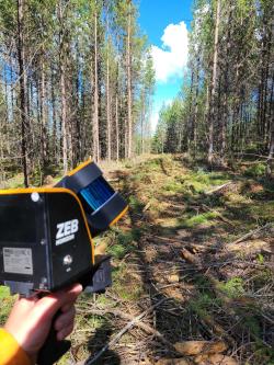
Using a handheld lidar scanner to assess a stand of thinned lodgepole pine enables researchers to determine tree structure and track growth faster and better than traditional methods.
As rising temperatures and droughts put more pressure on forests, monitoring is more vital than ever. “Stress weakens the trees and leaves them more susceptible to pests and insects,” says Greg O’Neill, Climate Change Adaptation Scientist at the B.C. Ministry of Forests.
O’Neill grows trees at test sites across the province, using seeds from different geographic sources to determine the best seedlings to reforest areas after they’re logged. However, assessing how well they’re growing is a big job.
Until now, that meant using height poles, diameter tape and other ground-based methods to capture a few basic measurements. And while aerial photography and satellite imaging offer a high-level view of the canopy, they don’t provide details of individual tree structures.
That leaves big knowledge gaps, especially when you’re assessing a 30-metre-high tree in the middle of a mature forest. How big is the crown? How long are the branches? How much chlorophyll do the leaves hold?
What makes these new forest monitoring approaches so powerful?
Coops is deploying CFI-funded remote sensing technologies to track forest health faster, and at a level of detail simply not possible with current approaches.
A handheld lidar scanning device allows his team to determine a tree’s structural characteristics from the ground. Drones equipped with multispectral cameras can scan the canopy from above, capturing and comparing the wavelengths it reflects to measure chlorophyll and pigment levels and detect the earliest signs of stress.
[This work] catapults the field of forest health assessment from medieval to the modern age.
Greg O’Neill, B.C. Ministry of Forests
Powerful computers at Coops’s Integrated Remote Sensing Studio then convert that data into 3D point clouds of individual tree structure, down to the centimetre, along with rich information about leaf chemistry. “The CFI grant allowed us to use variables that would otherwise be impossible to measure,” Coops explains.
Combining those 3D representations paints a picture of an entire forest that can inform everything from carbon sequestration monitoring to forest management decisions like when toharvest. That’s important for both economic and environmental sustainability.
“We derive huge benefits from knowing which seed sources will yield healthy, productive forests,” says O’Neill.
$87 billion
Content
Amount generated by Canada’s forest industries in economic activity in 2024
200 million+
Content
Average number of tree seedlings planted annually on public forest land in B.C.
How do you choose the right trees for a changing climate?
The drone-mounted cameras allowed O’Neill, Coops and former grad student Samuel Grubinger to measure thousands of trees at O’Neill’s test sites in a fraction of the time required for traditional methods, pinpointing which ones were growing best.
In addition, the multispectral data revealed how stressed they were. Combining this data with climate change models will help researchers predict which trees will thrive in which parts of B.C. in the decades to come.
“This is absolutely fascinating, revolutionary work that really catapults the field of forest health assessment from medieval to the modern age,” says O’Neill. “It opens up a whole new field of opportunity.”
Author : Julie Stauffer heads up Cadmium Red Communications, a boutique writing and editing agency that specializes in sustainability, engineering and health issues.
Climate change is threatening millennia of history in Newfoundland and Labrador. New LiDAR-equipped drones and other technology is helping archaeologists triage the sites at greatest risk and document crucial heritage before it disappears.