By using information found in historical records to create maps that can reveal otherwise invisible patterns, the University of Saskatchewan’s Historical Geographic Information Systems (HGIS) Laboratory is paving new paths for Indigenous and historical research methods in Canada.
Founded in 2006 as one of Canada’s first digital history labs, it is now one of the largest labs of its kind in Canada. The lab is expanding its capabilities with funding from the CFI for powerful computers that can merge large, complicated data sets that include millions of data points.
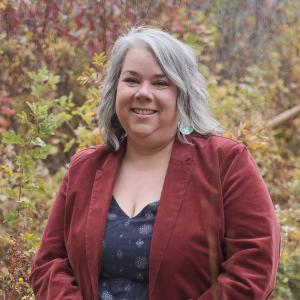
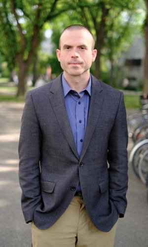
Cheryl Troupe, assistant history professor at the University of Saskatchewan, is co-leader of the CFI-funded research project along with the lab’s director and associate history professor, Benjamin Hoy.
Troupe’s research focuses on Indigenous and environmental history, specifically Métis communities in the 20th century in Western Canada. She merges oral histories with data sets such as government records and land allotment documents to create maps that show how stories from individual families and communities are connected to specific places. This allows those stories to be told in a spatial context, which helps to uplift Métis voices.
Troupe is a Métis woman from North Central Saskatchewan. “The work that I do is very personal,” she says.
She looks at the role of Métis women in food production and land use in 20th-century Métis communities in the Qu’Appelle Valley in southern Saskatchewan. She is interested in how families maintained their connections to land despite removal and displacement efforts. This work will appear in her upcoming book which is currently in peer review.
Both Hoy and Troupe’s research combine historical and geographic methods to analyze change over time and variation across space.
“By adding a latitude and longitude, you can find clusterings of points,” says Hoy. “The key to this — and the part that makes it really interesting — is you’re going to overlay data that would never normally fit together.”
His recent book, A Line of Blood and Dirt: Creating the Canada-United States Border across Indigenous Lands, which won the 2022 Governor General’s History Award, provides an example. In it, he combines oral and written records to map and analyze the physical, political and cultural relationships and conflicts that surrounded creation of the Canada-U.S. border.
His current research combines prison and federal deployment records (the movement of soldiers and supplies) from the late 19th and early 20th centuries. Hoy hopes to understand on a national scale how shortcomings in military logistics led to malnutrition and sickness in soldiers, limiting their ability to stop grassroots violence between Indigenous people and settlers.
Validating stories and understanding colonial pasts
The research produced using these new research tools can help Indigenous communities validate their oral histories, especially those surrounding land and place. In her research, Troupe says people shared stories like “We lived close to the reserve because we had relatives there.” Or, “We lived close to so-and-so because that was important.” Or, “Our families all lived in a specific area.”
On a map, you can locate more precise locations that match places to the stories, she says. “There’s a visual representation of how they understand their world and I think that’s very powerful,” Troupe says. “People that aren’t going to necessarily read academic work can see that representation in a different way.”
“People are really starting to respond to [this work],” she says. “Some of it is the culture of reconciliation and the results of the [Truth and Reconciliation Commission], but there’s also a genuine interest in people understanding the places they live.”
Pushing historical research into the future
Hoy says Canada is 20 to 30 years behind the United States and Great Britain in its digital information infrastructure, such as open access to public and government data records. This is something he would like to see changed through his work.
“One of my goals is to digitize and centralize a lot of Canada’s most important records,” he says. For example, he would like to digitize prison records with the aim of “putting large, important data sets that are fundamental to Canadian history into the hands of junior researchers and the public so they can begin to answer their own questions about Canada’s past.”
Hoy says HGIS offers a new way for historians to make original contributions to the field with little extra training. “Historians shy away from large data sets,” he says. “There is enormous potential here and the cool thing is you can learn how to do this in a few weeks.”
Troupe says the project is about building capacity among researchers from disciplines that don’t typically use spatial analysis. “Traditionally, historians have focused on archival records,” she says. “The ability to access digital data has changed how we as historians work and I think the work of the lab is really pushing that forward and that’s very exciting.”
The ability to access digital data has changed how we as historians work and the work of the lab is pushing that forward.”
— Cheryl Troupe, University of Saskatchewan


