Newfoundland and Labrador is rich in history. From Beothuk hunter-gatherers and Paleo-Inuit to Basque fishers, Viking explorers and British colonists, many have left their mark on the rugged landscape.
Today, climate change is putting that heritage at risk. Because so much of human activity over millennia occurred along the coastline, more than 80 percent of archaeological sites are threatened by storm surges and rising sea levels. In Northern areas, objects long preserved in the frozen earth have begun decaying as the permafrost melts. In some cases, entire sites are slipping off bedrock and into the ocean.
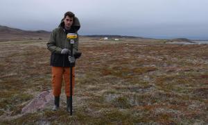
With the clock ticking, Memorial University archaeologist Lisa Rankin is adding 21st century technology to her traditional trowels, sieves and brushes. These new tools are helping her survey sites, track damage and identify the areas in greatest danger so they can be excavated before it’s too late.
Deploying drones for rapid data surveys
Traditional approaches to surveying are simply too time consuming, explains Rankin. That’s why she launched the North Atlantic Archaeology at Risk project, which focuses on the shorelines of Northern Labrador, Newfoundland and St. Pierre and Miquelon.
With funding from the CFI, she and her team are using ground-penetrating radar to detect buried features, specialized GPS equipment to map sites and portable X-ray devices to identify the chemical composition of artifacts impacted by climate change.
Then there are the LiDAR-equipped drones that allow them to capture scads of aerial images in a matter of hours. “It’s much, much faster than traditional archaeological approaches and allows us to cover a lot more ground,” Rankin says.
From above, drones can spot remnants of Inuit sod houses, Basque whaling factories or World War II bunkers. They can even detect changes in vegetation that indicate where humans once lived. Back at the lab, CFI-funded computers and specialized GIS software allow the researchers to crunch all that data, creating a clear picture of historical hotspots in jeopardy.
The equipment has been a welcome addition to the university’s Department of Archaeology. PhD candidate Deirdre Elliott is among the dozen graduate students who have benefited from it to date. She recalls travelling to remote Northern locations, where harsh conditions left only a 15-minute window for surveying. “Because I had a drone with me, I was able to collect so much data about what is happening at those sites. So I think it’s incredibly valuable,” she says.
Why archaeological salvage missions matter
Aerial surveys also make it much easier to visualize and measure changes — a crucial step in convincing policymakers and communities to protect key sites or salvage important heritage. “It definitely helps drive the point home when you can show two drone photographs side by side, and you can actually immediately see the change from year to year,” says Elliott. “Some places, we’re seeing losses of a metre a year.”
In addition to her own research, Elliott serves as the Heritage Program Coordinator for the Nunatsiavut Government, where she’s responsible for preserving archaeological sites on Inuit Lands in Labrador.
That work isn’t just key to understanding the past, she says. It’s also crucial for today’s Indigenous communities. Rankin agrees. “Their identity is tied to the landscapes that they inhabit and the places that they know about through oral traditions,” she says. “The loss of these places is a loss of their identity ... It’s a loss of their Knowledge and their way of life.”
Climate change is erasing important settler history as well. Rankin points to Labrador’s Red Bay, where Basque sailors established a vast whaling station in the 16th century. Today, coastal erosion caused by rising sea levels is swallowing this UNESCO World Heritage Site.
Then there are the financial impacts. Each year, tens of thousands of tourists flock to the province’s historical sites. Losing those sites would jeopardize a major source of income and jobs.
Leveraging high-tech tools and citizen scientists
As archaeologists around the world contend with climate change, Rankin’s cutting-edge approaches are transforming the discipline. “What having the CFI lab is allowing us to do is to not only get out there and do the work as fast as we can, but to train a whole new generation of archaeologists in these new, non-traditional techniques,” she says.
But even with high-tech tools, the scope of the task is daunting. To save as many heritage sites as possible, Rankin and Elliott see an important role for local communities. “We can’t get everywhere, but we need eyes everywhere,” says Elliott.
That’s where a new app being developed by the Nunatsiavut Government can play a role. The app will allow citizen scientists to record climate change impacts, sending GPS coordinates, photographs and other data to help Indigenous and provincial governments to monitor damage and make informed choices.
“We’ve got almost 10,000 years of history to try to preserve and thousands and thousands of sites. And we need these rapid, accessible methods to help us do it,” says Elliott. “It’s really changing the way we do archaeology.”
What having the CFI lab is allowing us to do is to not only get out there and do the work as fast as we can, but to train a whole new generation of archaeologists in these new, non-traditional techniques.”
— Lisa Rankin, Memorial University